Natural Beauties

Keybele

İncesu Canyon & Kybele Relief

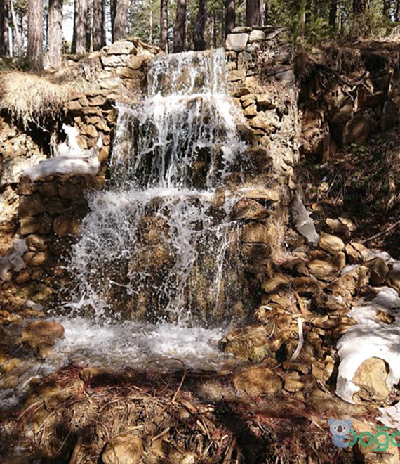
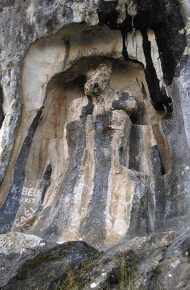
Located within the secrets of İncesi village in Ortaköy District and called Uzungeçit by the villagers, the canyon called İncesu Canyon in Çorum and Kazankaya Canyon in Yozgat is 12.5 km long. There are Alan Mountains with a height of 1363 meters in the east, and Malbelen Hill in the west. Both slopes of the canyon are steep rocks, and it is possible to come across forest areas in places. The canyon is suitable for rafting and trekking sports. The canyon, a natural wonder, is a place worth seeing. Trekking route: It starts from Yozgat Province - Aydıncık District - Kazankaya Town and ends in Çorum - Ortaköy - İncesu Village. It is thought that the track is suitable for rafting during periods when the water flow rate is intense. At other times, the canyon can be used as a hiking trail to observe a natural wonder. There are wall ruins dating back to the Hellenistic Period (2nd century BC) and stair-stepped water cisterns, called caves by the public, on the rocks rising on both sides of the canyon through which the Çekerek river, whose ancient name is Scylax, flows. The relief, which was first seen by Satulmuş UYSAL from İncesu village in 1985, is approximately 1 km from İncesu Village. In the distance, on the left side towards the direction of the water flow, there is a goddess relief on the rocks, 1.5 meters above the river bed. The goddess, built in a niche, overlooks the Çekerek (Scylax) river flowing in front of her and the castle located on high rocks opposite. The goddess, thought to be sitting on a throne, holds a lion cub in her left hand. It is said that she is Kybele with these features.

Nature Park

Çatak Nature Park

It is the city centre's most attractive and one-day excursion spot. The infrastructure of the recreation area, which is under the protection of the forest management, has been largely completed. Due to its natural structure, scenic richness and nature park characteristics, a 387.5 hectare section of the field was reserved in 1984. Çatak Nature Park is 22 km from the city center. distance, the road is asphalt and serves domestic tourism. It has natural structure, scenic riches and nature park features. The dominant tree species in the area is larch. A small amount of Scots pine can be seen. Fox, rabbit, wolf, songbirds and partridge make up the fauna. There are suitable tracks for trekking in the region. The first stage starts from the junction leading to Çalyayla Village and ends at Alagöz Plateau. This stage consists of 7 km. The second stage starts from Alagöz Plateau and after walking three km in the direction we came from, we return to Çatak Nature Park and walk another 2 km and end in the Çatak Nature Park Recreation Area. The entire track in question is 12 km long.

Kargi Plateau

Eğinönü Kargi Plateau

It is located in the high mountainous region in the north of Kargı district. It is 140 km away from Çorum and 26 km away from Kargı. Interconnected in the region; There are Eğinönü, Aksu, Karandu, Göl, Örencik, Karaboya and Gökçedoğan plateaus. In these plateaus, the tradition of plateau houses in accordance with the local plateau architecture still continues. It looks like a natural wonder with its trout grown in Aksu and Gökçedoğan ponds, which were built later, local vegetation and abundant water resources. In the forested and meadow areas around Kargı Plateau, which has 100 houses, electricity and an asphalt road, there are Dede Hill, Pirinççi, İki Çam, Lakes, Gidiler, Eyinönü Meadow, where the Ayın Oyun Fair was held in the past, Hacı Kıvrağ Gutter, Doctor's Gutter, Principal's Gutter, Cold Water, There are recreational areas such as Deli Ahmet Field, Taş Oluk Kuzu, Kıvrım Stream, Telere Spring, Weeping Pine and Kova. Kargı's famous Sırık Kebab is prepared in these places.

Abdullah Plateau

Kargı Abdullah Plateau

It is located in Kargı district and on Köse Mountain (2050 m.), which is the highest mountain in our province. The distance to Çorum is 114 km and 26 km to the district center. It is 12 km away from the highway that connects Istanbul to Samsun and passes through our Osmancık District. Depending on the destination, two different routes can be followed. The first of these is to reach the region via Osmancık Road by following the Istanbul - Samsun Highway, and the second is to reach the region via Osmancık Road by following the Ankara-Çorum Highway. It has a 22-bed accommodation unit, a restaurant for 120 people and a picnic area for 1000 people. The route of the trail, where trekking and horseback riding nature tourism can be done in the region, starts from Abdullah Plateau, and after passing through places known as Büklü Road and Otuziki Çatal Çam, it is completed at Oyunar Plateau. The track in question is 12 km long. Especially, watching the surroundings with binoculars from the fire watchtower on the Oyunar Plateau is a delight. It will also be very interesting to see the tree known as Thirty-Two Fork Pine, located on the route of the trail. It will be possible to reach Abdullah Plateau by following the Çorum-Osmancık-Kargı road, turning left after passing Hacıhamza Town and driving another 12 km.

Gölünyazı Wetland

Gölünyazı Wetland

The wetland known as "Gölünyazı" among the public in Kırıkdilim location on the Çorum-Osmancık Highway; It hosts a rich wildlife, especially water birds. It has a surface area of 265,282 m2. Wetlands; In addition to hosting very rich wildlife, it has functions and values that regulate the water regime of the region, soften the climate, and increase the quality of water by retaining sediment and toxic substances.